![]() |
SOUTH SLOPE SIDEWALK SALE VIRTUAL APPLIANCES |
IMBY: A Rear Window View of Brooklyn's South Slope
NEW ARCHITECTURAL VOYEURISM
Wednesday, November 27, 2019
Tuesday, November 19, 2019
A Fourth Avenue Protuberance
![]() |
When is the subway not a subway? When it's elevated |
On days when I'm not meant to be in any particular place at any particular time, I might find myself exiting the F train at the Smith and 9th Street stop for no particular reason.
I'm hovering now over the wanton Gowanus Canal some 88 feet above the ground. From this highest of all heights, I can watch a grounded worker below toss windows one after the other from the back of an albino box truck into a 40-yard dumpster. His partner standing in the midst smashes the plate glass with a metal rod and salvages the aluminum frames. The dumpster already contains a vast amount of glass shards. They've obviously been doing this for a long while.
From this heavenly place, one can almost certainly behold, day or night, an endless queue of 18 wheelers stranded absolutely still on the BQE. Their drivers again, almost certainly, believing they are in the wrong place at the wrong time.
Loitering as I do on the platform, I peer through its stainless steel mesh windows down into The Canal. When her surface is absolutely still, it reminds me most of a can of freshly spilled oil-based enamel paint spreading out in front of me, not quite the iconic color of historic Charleston's ironwork... Close to, but not exactly, Hunter Green with a fair amount of Lamp Black.
If I was as accomplished a painter as say John Singer Sargent I'd ask her to pose for me. Her portrait I would likely carry with me from place to place until my death.
![]() |
Herizon |
Thursday, January 10, 2019
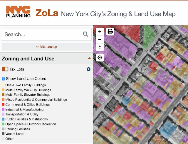
BIG DATA WEEK: ZoLa Show and Tell.
We're back on the ZoLa again!
Scroll down the feature menu to the very bottom under Basemaps and check the 3D feature, then check the Aerial Imagery box and you can choose any one of 11 different years dating all the way back to 1924 and as recently as 2016.
Over the years, we've covered a lot of new development in the South Slope. Here's one that we spent a good deal of time with...Lake Windsor a.k.a. 1638 Eighth Avenue, located between Windsor Place and Prospect Avenue. ZoLa offers us a chance to show off the property's unique, elongated land-locked lot over the history of development.
![]() |
In 2006 the building was demolished to make way for a multifamily development. |
![]() |
ZoLa's 3D mapping feature allows you to define current as built mass. |
![]() |
You can tilt and rotate your viewpoint. 1638 8th Avenue as seen from 8th Avenue. |
![]() |
1939-1940 Tax photo of 1638 8th Avenue from the NYC Municipal Archives. Over the years the property functioned as an office?garage for a home heating fuel oil delivery company. Old timers say that's where they would buy their block of ice for their home iceboxes. In 1922 ice plants in NYC and Long Island electrically manufactured over 1 million tons of ice, with an additional 20 tons of ice still being naturally harvested. |
ZoLa Pretty Data: New York City's Zoning and Land Use Beta Beauty


NYC Civic Technologists and Open Source Social Coders producing vibrant interactive maps and data visualizations that we here at IMBY Labs find optically arousing. The next generation of WEB MAPPING technology allows us to tilt, zoom, and rotate to our heart's content. Add this to your box of hammers. Clik for link ZoLa: NYC Planning and Land Use Map
What you got planned?
Weave your own layered BIGDATA tapestries.
Start with a base warp map of Zoned Building FootPrints, Aerial Imagery or 3D Building Masses then layer on the weft Districts...Residential, Commercial, Manufacturing, Community, Assembly, Senate, Council, Business Improvement, Limited Height, Historic.
Bedazzle it up on over the top with Flood Insurance Rates, Mandatory Inclusionary Housing Areas, Outdoor Sidewalk Cafe requirements and Transit Zones. Don't forget to check the box "Show Land Use Colors".
Tuesday, December 04, 2018
FOR SALE: 243 15th St. Wood Frame Tiny Home to Meet its Maker?
![]() |
Dug up these depression era 1940's tax photos showing the property in its glory days. Beautifully laid cobblestone street with trolly tracks. The lettering in the window says ROOFING. The adjacent faimily owned U. Santini moving and storage warehouse has been around since 1930. |
![]() |
Another photo of the property with the Tax Man in plain view. These 1940's photos are available for sale online at NYC Department of Records |
![]() |
Just in case they decide to demolish this home I thought I would record this detail of the original surviving cornice. |
![]() |
Aerial map showing the property (tiny pink square) and neighborhood as it existed in 1921. |
Thursday, October 25, 2018
IMBY TOOLBOX Casting Shade in NYC
Some people of the Earth are hard at work transcribing and converting our physical man made structures into digital bits. Rendering an accurate virtual illusion of the three dimensional world takes modeling skilz in order to fool the eye. Who's behind this Herculean effort?
A not for profit global community of data sharing freaks ( Open Geospatial Consortium, a.k.a. O.G.C.)
![]() |
Information Technology & Telecommunications Link to DoITT NYC 3D Building Model |
The Grey Lady created this interactive truth map of New York City's shadier bits. Click here to see who's living in the dark, CLICK LINK and the lite.
![]() |
From the New York Times Shadow map South Slope Winter Shade captured from their interactive map. |
![]() |
Summer Shadows, my new porn name. |
Awwww, Spring Fall Shadows!
Wednesday, October 24, 2018
Flavor Cannon of Mediocrity: New JUUL for 4th Avenue & 15th Street
Thursday, September 13, 2018
IMBY TOOL: NYC Active Construction
Ok my loyal followers, I have another great voyeur tool to appease our insatiable appetites. Play with this site awhile and see if it doesn't itch your scratch and scratch your itch.
NYC Active Major Construction
NYC Department of Building's Active Major Construction tool is an interactive map and dashboard that provides real-time insight into all currently active major construction sites. Buildings on the map are categorized by square footage, estimated cost, and proposed dwelling units with larger points denoting higher values. Click on any of the points to get more details as well as a direct link to the permit info on DOB's Building Information System (BIS). The sidebar also contains various interactive filters.
Scroll down to view daily Top 10 lists of active sites with the most square footage, most expensive, tallest, and most dwelling units. Additional Top 10 bar graphs show general contractors with the most active city-wide square footage and cost, as well as occupancy type information.
The data used to create this application consists of all active New Building (NB) and Alteration Type 1 (A1) Enlargement permits and is updated daily. (LINK)
![]() |
VOLUMINOUS DATA |
![]() |
New Architectural Voyeurism: Reimagining Brooklyn's Fourth Avenue
Subscribe to:
Posts (Atom)